
I don’t know a lot of things. In fact, you could fill millions of books with stuff I don’t know. But I do know this:
Google Maps and bad judgement are a dangerous combination. This is not a theory. I proved it last week.
It all started so innocently.
In an effort to expand Amazing Abruzzo Tours’ offerings, we purchased nine high-quality ebikes last winter. They are great machines with enough boost to allow people with a decent level of fitness to get out and enjoy the beautiful hilly landscape on the quiet roads around our hometown of Torre de’Passeri, Abruzzo, about 170 kilometres east of Rome.
The bikes and various routes are going to feature heavily in our Active Package relaunch in a couple weeks. That relaunch will be featured in an unashamedly self-promoting blog soon.
The point of this blog is to warn the world about the perils of someone who doesn’t know what they are doing, that’s me, using Google Maps to plan cycling routes in areas they are only slightly familiar with.

The start of the ride was so beautiful. I figured I was going to kill Instagram with these pictures.
Here, I need to say Google Maps is not the whole problem. When you plug in a destination and click the “bike route” option, it will indeed give you a route that’s been done before. The thing is it doesn’t say when the route was done, if it was done by a child on a tricycle or a professional mountain-biker, the quality of the road surfaces, or if it was a good ride or a stupid-as-all-effing-hell nightmare never to be repeated by any sane person.
For the latter determination, you must follow the route, and when you come to a dodgy bit, you need to rely on your own judgement. In my case, this presents another problem because this means I have to rely on my judgement, which generally ranges from confident to wildly over optimistic.
Remember, my wife and I quit our well-paying jobs in Canada, sold everything we owned, and moved to a country we’d never lived in, where we didn’t speak the language. There we bought an old, rundown villa, renovated it, and opened a tour company.
And I was confident it would work.
So, mapping some cycling routes? Piece of cake. Right?
By last week, I’d done a few shorter loops near our town, and I started looking for longer rides that could fill a whole day but weren’t too hilly or on really crappy roads.
I settled on the village of Civitaquana in the foothills about 20 kilometres away as the first leg of a possible loop. I plugged it into Google Maps, hit the cycling icon, and it produced the “best route” with the caveat that there was a section of “very steep hill.”
I’m in pretty good shape and after six weeks of ebiking experience, I was confident I could handle the “very steep hill” at the 15-kilometre mark. The first bit took me on good paved roads I knew, but at about the 10-kilometre mark, the Google navigator lady told me to turn left on a dirt road that led down into a valley.
The road was in good shape and I could always turn around if it got bad. Right? I proceeded.
When the road turned to gravel, it was no big deal. Google Maps told me I was on the best route. How could this go wrong. Right?
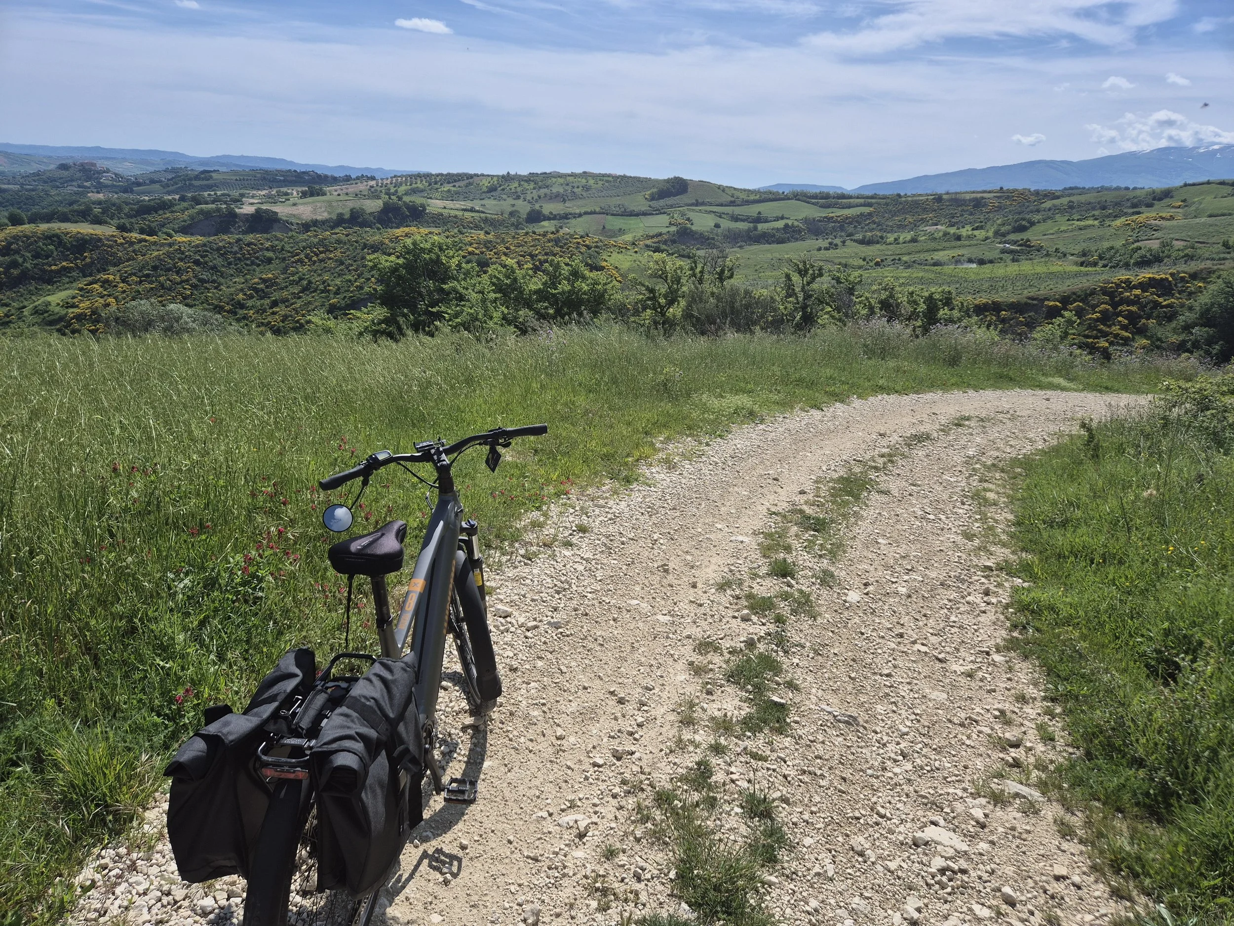
About a kilometre later, the road turned into a nice country gravel path with weeds growing in the middle. It went along a beautiful ridge, passing vineyards. I felt exhilarated. So sweet. I stopped to take pictures I planned to use to promote our new ebike tours.
After about three kilometres, the road started to descend into the heart of the valley and it became a little rough as the slope increased. Nothing major. I kept going.

I was even OK with this level of road condition. It was fun.
The slope then increased and a few washouts appeared due to the recent rains. The bike tires started slipping a bit, but the challenge was fun, like when I was a kid riding my bike on the country paths around the farm I grew up on. I didn’t even mind it when the road turned a bit rougher. I felt alive.

I didn’t have the presence of mind to take a picture of my crash site, but this picture is pretty close to what it looked like, only steeper.
Then the “road” made a hard right, turned into what looked like a dry creek bed and plunged down toward to the valley floor. I braked hard, and my right leg slipped off the pedal, which then scraped down my shin like a filet knife deskinning a salmon. Pain shot up my leg as I skidded and bumped over rocks for about 50 metres. As I struggled to keep the bike upright, I crushed my crotch on the seat and lost the pedals several time before I could stop/crash against a big rock on the side of the “road.”
My crotch felt like it had been pushed into my stomach and would require a surgical miracle to extract. I checked my leg and it was more of a bloody delayering than tear of the skin. So that was good.
Ahead of me, the “road” was a 150 metres rock fall to the valley floor. I looked at my phone screen and it still said I was on the “best route” with the “very steep hill” on the other side of the valley floor.
Decision time.
According to Google, if I turned around, I would have to pedal four-kilometres back out of the valley then do a 10-kilometre detour to Civitaquana; or, if I kept going it looked like about 500 metres of rough road and then about 300 metres of “very steep hill” and then good roads again.
How bad could it be, I thought.
I bounce-walked the bike down the washout to the valley floor, crossed a stream, and saw another washout going straight up the other side. I figured it was like what I just came down, so I’d walk up, and in a couple hundred metres, the road would improve and I’d be on my way. But I checked my phone, and the navigator was telling me to turn right. I looked right and saw a rough animal path disappearing into a field of overgrown, like head high, flowery looking weeds. The phone said only a couple hundred metres of that, a sharp left turn, and then the “very steep hill.”
I took stock. I figured, I was on the valley floor now, so going back was going to be as difficult as going forward.
I got on the bike and plowed into the forest of weeds. After about 100 metres, I notice a stinging, itchy feeling on my legs. Weeds can be like that and I’m not allergic to anything. I continued for another 100 metres and then the navigator told me to turn left, but there was no left turn, just more weeds and an increasing slope.
I went a bit further on the “path” to see if there was another left turn. Nope. I backtracked to see if I’d missed the turn. Nope.

Looks nice, eh? It wasn’t. It sucked.
It was then that I realized how hot it was and how the stinging in my legs was turning into a burning, chemical fire of pain like I’d just waded through a pool of battery acid. If I could have jumped out of my own skin, I would have.
By this time, I was fully committed to moving forward. It couldn’t get worse.
I started up the hill, but as the slope increased my trekking bike tires started slipping on the moist foliage and clay mud. I got off the bike, started pushing and was immediately surprised by just how heavy an ebike is. To be exact, mine weighs somewhere between “Holy Shit” and “I can’t believe how stupid I am.”
The slope increased and my feet started slipping. I started grinding out 10 metres at a time, then doubling over for a minute or two sucking air. Sweat poured down my body. The skin on my legs felt like it was melting off. My stomach/crotch ached. I was dizzy.
So, when I came to a relatively flat area, I stopped for a drink of water.
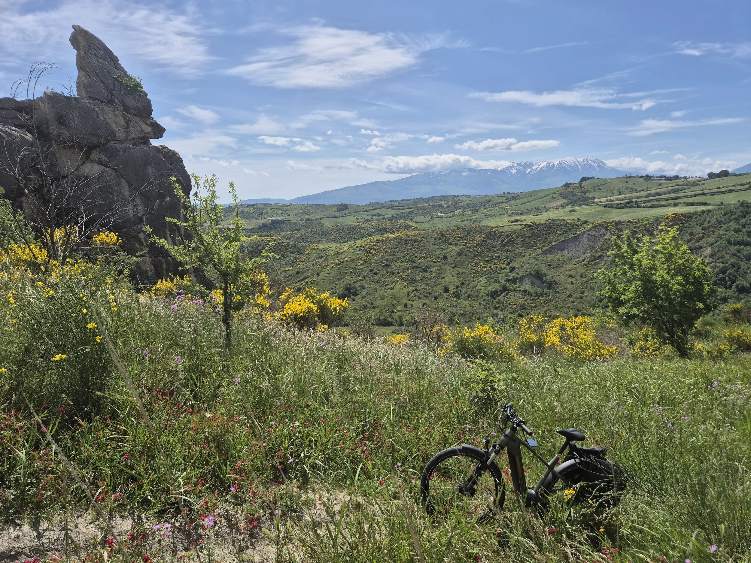
The mean-spirited God Rock silectly mocking me. I just about turned back here.
And then it appeared – a rock sticking out of the very steep hill. Not just any rock, but a rock that to me looked like an all-knowing God that sat silently watching my tribulations like it had seen this movie before. It was the Rock of Bad Judgement, and it was judging me poorly waiting for me to admit defeat and turn around.
I actually told that rock, out loud, that it could go eff itself.
For the next 45 minutes, I pushed that bike up that hill a few metres are a time through what looked like nice wildflowers and felt like razor-blade weeds. I fell. My legs ached. My crotch/stomach felt like an angry troll was kicking me from the inside. Sweat burned my eyes. I cursed technology. I cursed my judgement. I cursed whoever tricked Google Maps into thinking this route was the best … effing … route to Civitaquana from Torre de’Passeri. I cursed that stupid god rock as millimetre by millimetre the phone confirmed that the very steep hill was coming to an end.
Eventually, the razor blade foliage became less dense, the hill flattened out and an animal path outline emerged, grew bigger and gave way to a sort of road. I passed a group of Abruzzese shepherd dogs that just stared at me. I looked for the bones of the last person who tried this route. I swear to God one of those dogs was smiling derisively.
But then came a rough road a 4x4 could handle and I could pedal again. Quickly came a real dirt road and then a paved road.

The rest of the ride was lovely.
My immediate ordeal was over and I continued on my way, eventually mapping out a wonderful intermediate difficulty day loop – that doesn’t follow the “best route” or include the “very steep hill.” In fact, a couple days later I redid that section of the loop and with a slight change in road selection, you stay on good paved roads, get better views and 100 per cent less crotch smashing and leg stinging, a-hole, razorblade flowers.
How did I find that route? Google Maps. It works as long as you have good judgement. I will continue using it.
And I will print out a picture of that God rock and hang it on wall to remind myself that my judgement is suspect at best.
Stupid rock.

Eff you stupid rock.